Alabama Certified Animal Waste Vendor Training
Module 3. Spreadable Acres
All fields have areas where fertilizers and manures cannot or should not be applied. These may be wooded areas, drainage areas, streams, marshes, and buffers and setbacks as required by NRCS Code 590. All producers who plan to use animal manure/poultry litter as a source of nutrients on crops or forages are supposed to have some type of nutrient management plan.
 |
This plan should include an aerial photograph or map of all fields where manure or fertilizers are to be spread with the buffers and setbacks clearly marked and the SPREADABLE ACRES identified. Spreadable acres are always less than the actual field acreage. The following description goes through the "official way" NRCS or a consultant would go about calculating the spreadable acres in a field.
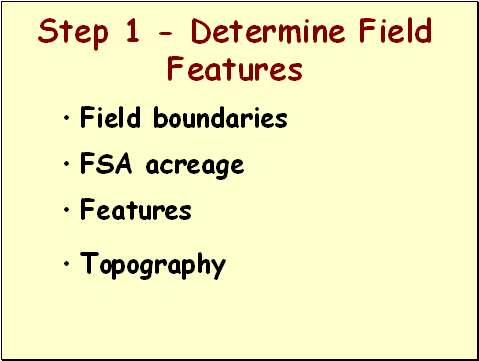 |
The first step is to determine the field features. You must have a map to start this process. An FSA (Farm Services Agency) map should have the field boundaries identified with the field acreage shown. Notice other features such as streams, ponds, houses, woods, etc. Topography (or the lay of the land) also is important. Topography can be obtained from a USGS topographic map (http://www.topozone.com)
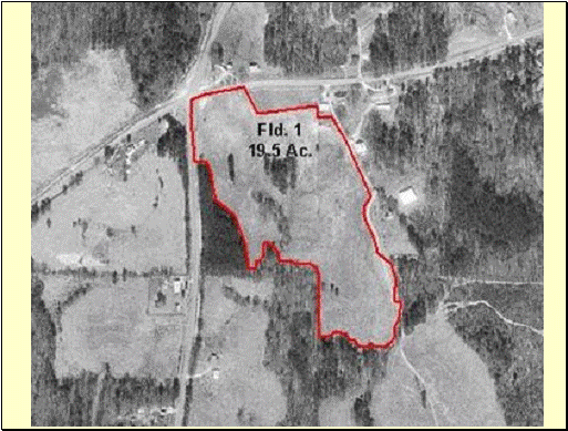 |
Here is a typical FSA (Farm Services Agency) map for a field to receive litter. The field has a total of 19.5 acres. This is the FSA acres.
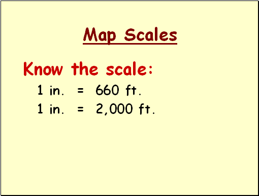 |
Be sure and know the scale of the map you are working with. The scale will be important to make calculations.
 |
The second step is to determine where the runoff water leaves the field. A map showing field elevation contour lines (a topographic map) can be used to do this. Water always runs off downhill and perpendicular (at right angles) to the contour lines. It is also important to do a drive around of the field to determine exactly how the runoff water leaves the field.
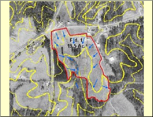 |
The blue arrows on this map show how the runoff water flows from the field.
NOTE: arrow in lower right-hand corner of map is POINTING THE
 |
The next step is to determine the buffers that apply for the field and to calculate the acreages associated with each buffer. These acreages will be deducted from the FSA acreage of the field.
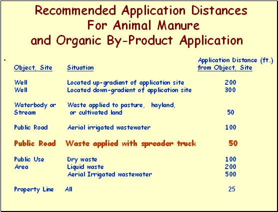 |
Here are the recommended buffer distances from the NRCS Code 590 standard. Notice the buffer for the public road.
 |
Roads are next to the NW corner of the field. A total of 600 linear feet of 50-ft buffer is needed. This equates to 0.7 acres.
600 ft. x 50 ft. = 30,000 square feet
30,000 sq. ft. ÷ 43,560 sq. ft./acre = 0.688 acres or about 0.7 acre
 |
Remember that it takes 43,560 square feet to equal one acre.
Rule of Thumb: For 50-ft wide buffers, it takes about 900 linear feet to equal 1 acre.
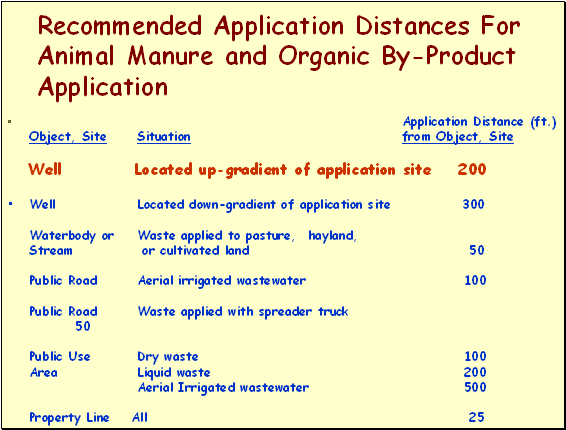 |
At this location, a well is located near the property line and is “up-gradient” from the application of litter. Application distance is 200 feet from the well.
 |
A circle with a 200-ft radius is 2.9 acres while a circle with a 300-ft radius is 6.5 acres.
 |
A buffer with a 200-ft radius should be drawn on the map. The buffer is estimated to be approximately 1 acre since it is less than ½ of the circle.
 |
The spring creek in the field should also have a buffer.
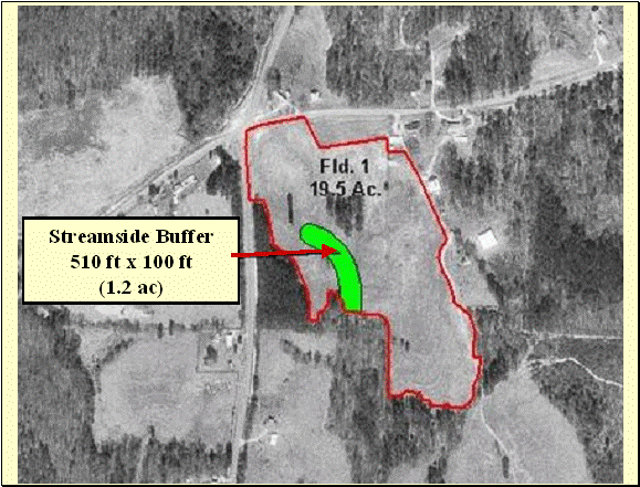 |
The streamside buffer should be at least 50 feet on each side of the stream (100 ft total). This buffer should be a grass filter strip. We measure the length to be 510 ft and the acreage to be 1.2 ac.
100 ft. x 50 ft. = 50,000 square feet;
50,000 ÷ 43,560 = 1.15 acres or approx. 1.2 acres
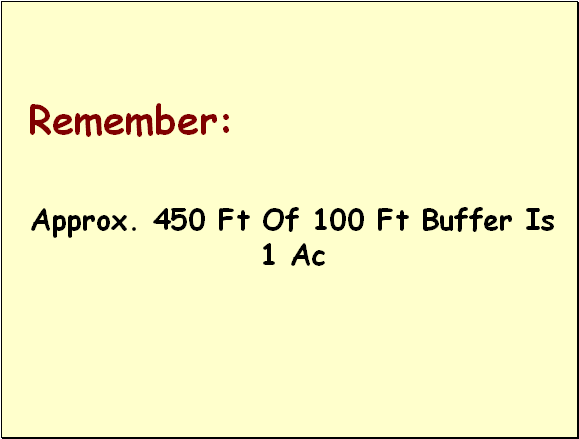 |
It takes about 450 feet of 100-ft buffer to equal 1 acre.
 |
Remember, where runoff leaves a field it must pass through either a 50-ft grass filter strip or 20 feet of grass filter associated with a riparian forest buffer. A "riparian forest buffer" is simply an area of undisturbed trees or shrubs that serve as a filter strip around streams.
 |
The 20-foot width of grass associated with the riparian buffer is estimated to be 1,150 feet long. This equals 0.5 ac.
1,150 ft. x 20 ft. = 23,000 square feet
23,000 ÷ 43,560 = 0.53 acres (approximately 0.5 acres)
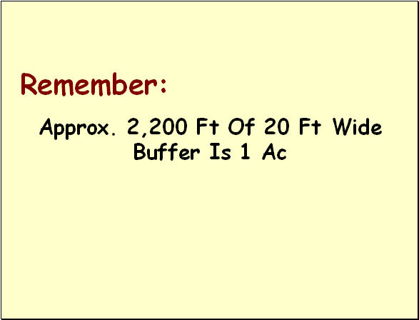 |
It takes approximately 2,200 feet of 20-ft buffer to equal 1 acre.
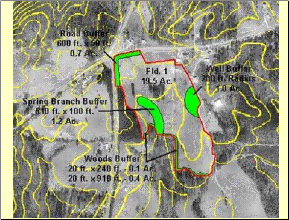 |
Here are all the buffers we have so far.
 |
Another feature of the field is some woods that are within the boundaries of the field. These can be estimated by using an average length and width.
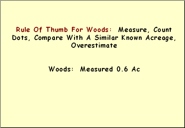 |
Use a scale to measure to figure the woods area. NRCS uses a clear template that has simple dots scaled to different map scales that allows placing the template over the woods area and "counting the dots" enclosed by the woods boundary. Total # of dots will give square footage of the woods (or any area in question).
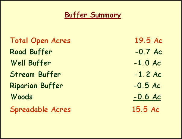 |
Step 4 is to deduct the buffer and exclusion acreage from the FSA acreage to determine the SPREADABLE ACRES for the field.
15.5 acres of the 19.5 acres field can be used for spreading animal manures/litter.
 |
This aerial photo is marked with the buffers and setbacks used in this field. SPREADABLE ACRES is shown to be 15.5 instead of the 19.5 total field acres shown.
Please return to the Course Content page (click >Course Content...> on the WebCT navigation bar at the top of this window) to take the Self-Help Test for this Module.